A practical guide to bird watching in Sonoma County, California
(Unless otherwise indicated, all phone numbers are in the 707 area code)
A practical guide to bird watching in Sonoma County, California
(Unless otherwise indicated, all phone numbers are in the 707 area code)

Skaggs Island Rd. (south end)
Location aliases: None. Note, however, that there are two distinct stretches of Skaggs Island Rd. This page refers to the southernmost section of the road, which begins at Hwy. 37 and ends only about a mile north at a fenced-off area. This was formerly one of the entrances to a naval base that was here, no longer in operation. Local birders are very cavalier about the use of the name Skaggs Island Rd.--often not bothering to say whether they mean the north stretch or the south stretch. If in doubt, ask.
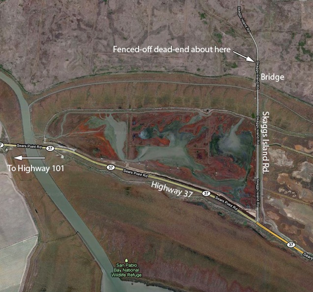
NOTE: As of early 2015, the road into this area from the south has been closed to vehicles. It may still be possible to walk into this area.
Location: Entrance to the south end of Skaggs Island Rd. is via a turnoff from Hwy. 37 (marked on the underlying Google map here as "Sears Point Rd.," although I have never heard Hwy. 37 referred to by that name locally). Hwy. 37 can be reached from the north, via Hwy. 101 or via Lakeville Hwy. (or Arnold Dr., the southern end of Route 121)--all off the map above to the left. From Hwy. 101, use exits marked for Hwy 37. Lakeville Hwy. ends at Hwy. 37 at a T-junction (its extension south is Reclamation Rd.). For birders that care about county lines, this is close to the junction of Sonoma Co., Solano Co., and Napa Co. See Sonoma County Overview for information on determining county borders.
GPS address: Addresses are very tricky in this case because Skaggs Island Rd. is split in two by the closed-off, abandoned naval base (to complicate matters, the road within what was once the base is a loop with two extensions, all sections of which have the same name--Skaggs Island Rd.). As a result, all GPS addresses on Skaggs Island Rd. are likely to be unreliable. I will update this page if I can find a useful address.
If your GPS allows you to enter a location using road intersections, try Skaggs Island Rd. and Sears Point Rd. or Hwy. 37 (Hwy. 37 and Sears Point Rd. are one and the same). An address of 29000 Skaggs Island Rd. (the only address my GPS recognizes) will take you to the part of Skaggs Island Rd. that is accessible from the north (the portion north of the abandoned naval base). That is not what you want in this case. If you can't enter an intersection, try coordinates, below, if your GPS allows it.
GPS Coordinates: The intersection of Hwy. 37 and Skaggs Island Rd. is at 38.1489N, 122.3806W (or 38 08 56N, 122 22 50W). Failing that, look at a map. The southern part of Skaggs Island Rd. is accessible only from Hwy. 37. Skaggs Island Rd. intersects Hwy. 37 well to the east of Hwy. 101 and to the east of Lakeville Hwy.
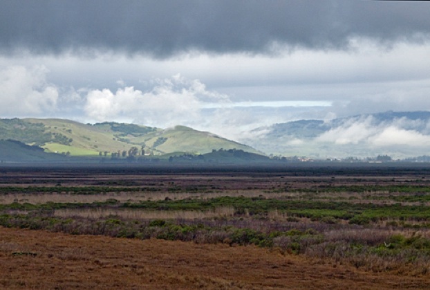
Recommended route: The best areas tend to be on the west side of the road (to your left as you head toward the bridge and the dead end, away from Hwy. 37). The bridge just before the end of the road offers good views, as noted above. It can be an excellent spot for seeing a wide variety of raptors, including kites, Northern Harrier, Rough-legged Hawk, Kestrel, Peregrine Falcon, and Ferruginous Hawk. The photo is a view from the bridge on a cold, rainy, winter day.
Habitats: Tidal mud flats, marshlands, scrub
Typical Species: Great Egret, Snowy Egret, American Coot, Northern Shoveler, Gadwall, Green-winged Teal, Wigeon, Mallard, Greater scaup, Ruddy Duck, Sora, Virginia Rail, Greater Yellowlegs, American Avocet, Killdeer, Willet, Marbled Godwit, Long-billed Curlew, Long-billed Dowitcher, Black-necked Stilt, Black-bellied Plover, White Pelican, Western Sandpiper, Least Sandpiper, Western Gull, Ring-billed Gull, Red-winged Blackbird, Brewer’s Blackbird, Turkey Vulture, Red-tailed Hawk, Northern Harrier, Cooper's Hawk, American Kestrel, White-tailed Kite, American Crow, Black Phoebe, Say’s Phoebe, Raven, Western Meadowlark, Marsh Wren, Tree Swallow, Yellow-rumped Warbler, House Finch, Starling, American Pipit, Song Sparrow, Savannah sparrow, Golden-crowned Sparrow, White-crowned Sparrow
Unusual birds, sightings: Short-eared Owl (January 5, 2012); Short-eared Owl (January 1, 2012, Ruth Rudesill); Rough-legged Hawk (February 19, 2011).
Restroom facilities: None. Closest restrooms are at Port Sonoma Marina.
Restaurants nearby: Nothing in the immediate vicinity. There is a Starbucks at 3100 Lakeville Hwy. (775-3708) for the basics. Otherwise, Petaluma (further to the north) is probably the best bet for lunch in the area. My favorite in Petaluma has long been the Water Street Bistro at 100 Petaluma Blvd. North, Petaluma, CA 94952 (763-9563). Small, but delicious. Lombardi’s Barbecue (3413 Petaluma blvd. North, Petaluma, CA 94952; 773-1271) has excellent sandwiches. Try the pulled pork sandwich. Ask for your cole slaw IN the sandwich. Yum.
Nearby attractions: The historic downtown area of Petaluma has restaurants, galleries, antique and other shops, mainly on Kentucky St. and the surrounding areas. Good for a stroll and shopping. This area has some good Victorian architecture. If you’re in the mood for bargain hunting, the Petaluma Village Factory Outlets outside of town may be of interest, at 2200 Petaluma Blvd. North (778-9300). Petaluma has a nice Carnegie Library still in operation that houses a small museum of local interest. (built in 1904; 20 Fourth St., Petaluma, CA 94952). For the gardener, Cottage Gardens is an excellent nursery, at 3995 Emerald Dr., Petaluma, CA 94952 (778-8025).
Related bird watching spots: The closest birding spots are at Reclamation Rd. and Port Sonoma. See relevant pages for details. Shollenberger Park is about 20 minutes north of Port Sonoma, in Petaluma. Adjacent to Shollenberger Park is Ellis Creek Water Recycling Facility. On the opposite side of Shollenberger Park from Ellis Creek Water Recycling Facility is Alman Marsh. See the pages for Shollenberger Park and Ellis Creek Water Recycling Facility for details.
Further afield: To the south is the San Pablo Bay National Wildlife Refuge (mostly in Solano County), but I've never been able to figure out how you actually get to the Refuge. To the west, you can head back to Highway 101 or Lakeville Hwy. The Atherton Rd. exit from Hwy. 101 gives access to good birding at wetlands accessible from Bahia Dr. (Marin County). Head for the intersection of Bahia Dr. and Topaz Dr. A GPS address of 500 Bahia Dr., Novato, CA should get you close. 1600 Armstrong Ave. should take you close to good birding along Binford Rd., on the other side of the same area (heading toward Gnoss Field, a small airport here). Trails connect the two areas.
Notes: This is a road to nowhere. It has a remote and isolated feel. While I'm not aware of any trouble having been reported, it may be best avoided alone.
All photos by the author, unless otherwise indicated
Maps by Google Maps
© Colin Talcroft, 2009, 2010, 2011, 2012, 2013, 2014
Unless noted, all photos by the author. If you would like to use one of my images, please ask for permission for non-commercial use with proper credit or commercial use with proper compensation.