A practical guide to bird watching in Sonoma County, California
(Unless otherwise indicated, all phone numbers are in the 707 area code)
A practical guide to bird watching in Sonoma County, California
(Unless otherwise indicated, all phone numbers are in the 707 area code)

Hudeman Slough/Hudeman Slough Wetland Enhancement Project
(Also the Huichica Creek Unit of the Napa-Sonoma Marshes)
Location aliases: Hudeman Slough proper is a slough just to the southeast of the Hudeman Slough Wetland Enhancement Project, the latter an area of managed wetlands and water storage ponds accessible from Ramal Rd. (see Access below). The area that birders visit and refer to as “Hudeman Slough” is actually the Wetland Enhancement area. Sometimes casually referred to by birders as just “Hudeman.” For information about the Huichica Creek Unit of the Napa-Sonoma Marshes, see notes at the bottom of this page.
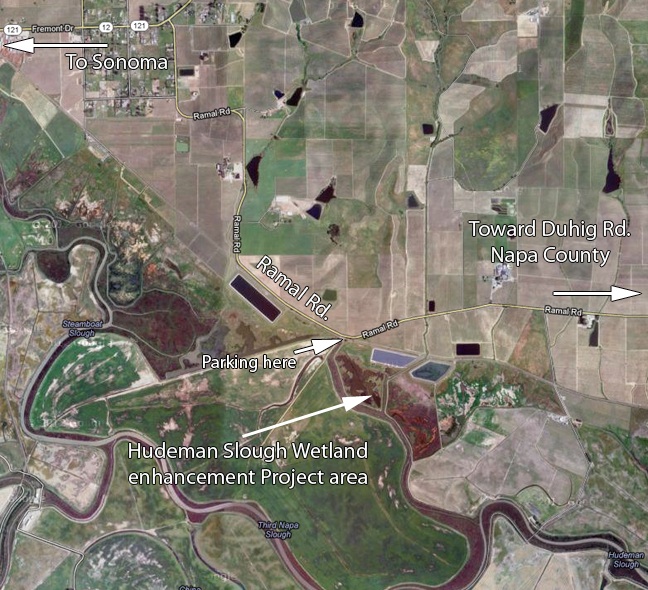
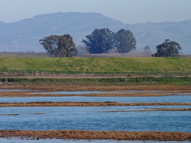
Location: The Hudeman Slough Wetland Enhancement Project is one part of a managed system of water storage ponds, wetlands, and sloughs in the southeastern corner of Sonoma County. The large complex of marshes and sloughs that straddles the southernmost parts of Sonoma and Napa Counties is referred to as the Napa-Sonoma Wetlands or Napa-Sonoma Marsh. The Hudeman Slough Wetland Enhancement Project area is one small part of the complex, which extends south to San Pablo Bay. The birding area referred to here is limited to the wetlands and ponds visible from the dykes near the parking area off Ramal Rd.
GPS address: The parking area is near 25700 Ramal Rd, Sonoma, CA 95476
GPS Coordinates: The small parking area off Ramal Rd. is at 38.2211N, 122.3953W
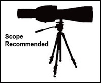
Recommended route: The “trails” here are not well designed to make a circuit of the area. You can avoid some backtracking by going briefly off the dykes (officially frowned upon) in some places, although high water can make shortcuts impossible. Simply walking along the dykes gives good views of the water. Scope recommended, as the birds tend to stay well out from the dykes. The seasonal ponds close to the parking area can be productive, as can the large water storage ponds, which are not really visible unless you climb up them.
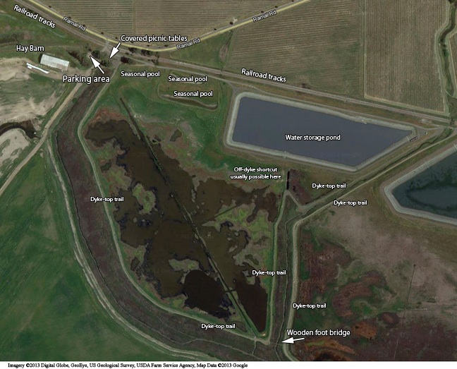
Habitats: Tidal mud flats, marsh, sloughs, seasonal pools, water storage ponds, scrub
Unusual birds, sightings: Solitary Sandpiper (9/4-9/6/16, Murray Berner); Ruff (9/6/16, Rob O’Donnell); Stilt Sandpiper (11/29/13-1/4/14, Eugene Hunn); Ruff (10/31-11/1/13, Eugene Hunn); Eurasian Wigeon (Mar 10, 2013, Murray Berner); Eurasian Wigeon (Feb 22, 2013, Bob Battigan); Canvasback (Jan 31, 2013, Colin Talcroft). Bonaparte’s Gull (Jan 31, 2013, Colin Talcroft); Blue-winged Teal (Jan 4, 2013, Gene Hunn); Redhead (Dec 4, 2012, Bill Doyle); Loggerhead Shrike (Sep 10, 2012, Susan Kelly); Light morph Swainson’s Hawk (Aug 8, 2012, Katheen Mugele); Bald Eagle (May 27, 2012, Don Bartling); Whimbrel (May 25, 2012, Kathleen Mugele); Red-necked Phalarope (May 6, 2012, Don Reinberg); Solitary Sandpiper (Apr 27-May 1, 2012, Alan Wight, Ruth Rudesill, Joseph Morlan, Colin Talcroft, others); White-faced Ibis (Apr 19, 2012, Gene Hunn); Blue-winged Teal (Apr 19, 2012, Gene Hunn); Eurasian Teal (Feb 26, 2012, Murray Berner); Ruff (Dec 8, 2011--this bird overwintered, at least through March, Murray Berner)
Restroom facilities: Portable toilets at the parking area.
Restaurants nearby: Nothing in the immediate vicinity, but the small, charming town of Sonoma has numerous shops, galleries, and restaurants. Among the restaurants, I recommend the Plaza Bistro (420 1st East, 996-4466), The Swiss Hotel (18 West Spain St., 938-2884), and La Salette (452-H First St. East, 938-1927) for dinner. Maya Restaurant (101 E. Napa St., 935-3500) is good for South American-style lunch. Plaza Bistro hosts excellent jazz nights--not to be missed if you’re a serious jazz fan. Mission Sonoma is at the north end of the town’s central plaza--the northernmost of the Spanish missions. California’s flag first flew in the square here.
Related bird watching spots: The closest birding spots are at Skagg’s Island Rd., Reclamation Rd. and Port Sonoma. See relevant pages for details. Shollenberger Park is in Petaluma. Adjacent to Shollenberger Park is Ellis Creek Water Recycling Facility. On the opposite side of Shollenberger Park from Ellis Creek Water Recycling Facility is Alman Marsh. See the pages for Shollenberger Park and Ellis Creek Water Recycling Facility for details. Also convenient, especially if you’re coming or going through Kenwood to the Santa Rosa area, are Sugarloaf Ridge State Park and Sonoma Valley Regional Park, as well as Hood Mountain Regional Park. For Santa Rosa area bird watching spots, see the front page.
Further afield: To the south is the San Pablo Bay National Wildlife Refuge (mostly in Solano County), but I've never been able to figure out how you get to the Refuge. To the west, you can head back to Highway 101 or Lakeville Hwy. The Atherton Rd. exit from Hwy. 101 gives access to good birding at wetlands accessible from Bahia Dr. (Marin County). Head for the intersection of Bahia Dr. and Topaz Dr. A GPS address of 500 Bahia Dr., Novato, CA should get you close. 1600 Armstrong Ave. should take you close to good birding along Binford Rd., on the other side of the same area (heading toward Gnoss Field, a small airport here). Trails connect the two areas.
Notes: 1. Hudeman Slough seems to be an area that shooters like to use for target practice. I’ve never heard of anyone having any trouble, but I’ve visited the place while people have shown up to take pot shots at targets nearby. I simply move on.
2. The Huichica Creek Unit of the Napa-Sonoma Marshes refers to a wildlife area just to the east of the Hudeman Slough Wetlands Enhancement Project. Head east on Ramal Rd. (turning right out of the parking area) from the Enhancement Project area and turn left (north) at Duhig Rd. Take the first right, onto Las Amigas Rd. to head east again until Buchli Station Rd. Turn right (now heading south) onto Buchli Station Rd. until it ends at the wildlife area parking lot (there is a jog to the right at the very end). If you care about county lines, this area is in Napa County (the eastern boundary of the two counties on Ramal Rd. is about a quarter mile before the bend in Duhig Rd.).
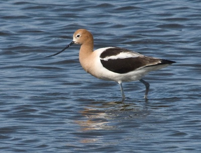
The bird in the photo: American Avocet, Hudeman Wetlands Enhancement Project, May 1, 2012
All photos by the author, unless otherwise indicated
Maps by Google Maps
© Colin Talcroft, 2009-2016
Unless noted, all photos by the author. If you would like to use one of my images, please ask for permission for non-commercial use with proper credit or commercial use with proper compensation.