A practical guide to bird watching in Sonoma County, California
(Unless otherwise indicated, all phone numbers are in the 707 area code)
A practical guide to bird watching in Sonoma County, California
(Unless otherwise indicated, all phone numbers are in the 707 area code)


Melita Rd., Santa Rosa, CA 95409
Location aliases: Not sufficiently on the local bird-watching radar to have nicknames.

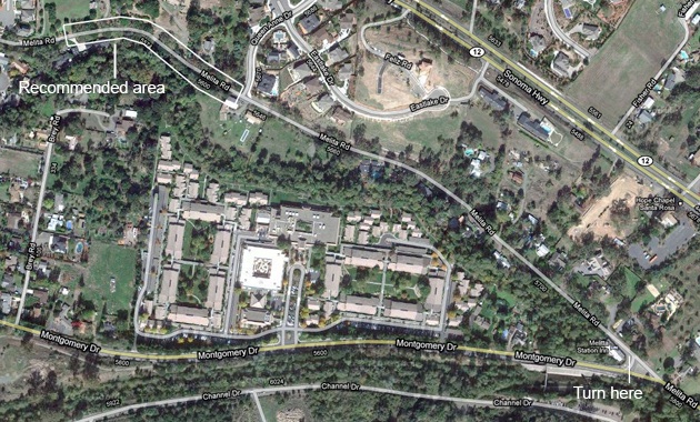
Location: Melita Rd., Santa Rosa, California, 95409 (the stretch north and west of the intersection with Queen Anne Dr. See map for details).
GPS address: 5646 Melita Rd., Santa Rosa CA 95409 (approximate)
GPS Coordinates: 38 27 38N, 122 38 40W (to be confirmed)
Access: Parking limited. Narrow road. Be sure your vehicle is as far off the road as possible and avoid parking on blind curves. Approach from Montgomery Dr., turning at the Melita Station Inn. (The recommended area is enclosed at the upper left on the map.)
Habitats: Residential, creekside undergrowth, mature oaks
Unusual birds, sightings: Yellow Warbler; White-throated Sparrow (Apr. 2010)
Restroom facilities: No public facilities nearby
Restaurants Nearby: No notable restaurants in the immediate vicinity, but, if you're heading east from here, there is a Safeway with deli at the intersection of Hwy. 12 and Calistoga Rd. In the same shopping center there are a number of fast food places as well. Heading further east out Highway 12 toward the town of Sonoma, Café Citti, 9409 Sonoma Highway (833-2690, Highway 12 by another name), in Kenwood, has good sit-down Italian food. There are also restaurants in the town of Glen Ellen. Heading in the opposite direction, to the west on Hwy.12, there is a deli in the Safeway at 2751 Fourth St. 522-1455. Michelle Marie's Patisserie, 2404 Magowan Dr. (in the Montgomery Village Shopping Center; 575-1214) has sandwiches and full meals at lunchtime.
Nearby attractions: Heading out Highway 12 in the direction of Kenwood (east) takes you into the heart of the Sonoma Valley wine country. Many wineries offer tastings.
Related bird watching spots: Spring Lake Park, Lake Ralphine, and Channel Dr. are the closest substantial areas. Arroyo Sierra Dr. is accessible from Hoen Ave. Strawberry School Park is close by as well, accessible from Summerfield Rd. Further east, on Hwy. 12, is Sugarloaf Ridge State Park. See individual location pages for details.
The bird in the photo: Western tanager, Melita Rd., September 2010
All photos by the author, unless otherwise indicated
Maps by Google Maps
© Colin Talcroft, 2009, 2010, 2011.
Unless noted, all photos by the author. If you would like to use one of my images, please ask for permission for non-commercial use with proper credit or commercial use with proper compensation.