A practical guide to bird watching in Sonoma County, California
(Unless otherwise indicated, all phone numbers are in the 707 area code)
A practical guide to bird watching in Sonoma County, California
(Unless otherwise indicated, all phone numbers are in the 707 area code)

Willow Creek Rd., Jenner CA 95450
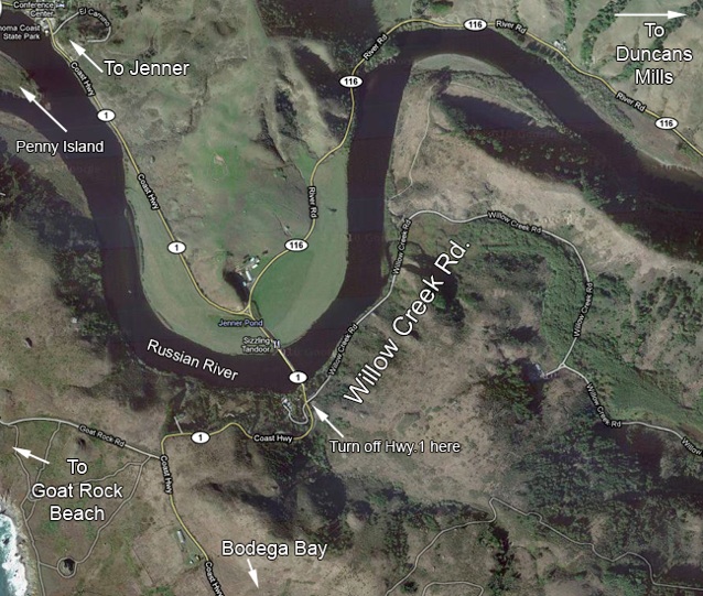
©2011 Google – Imagery ©2011 DigitalGlobe, USDA Farm Service Agency, GeoEye, Data CSUMB SFML CA OPC, Map data ©2011 Google
Location: Off of Hwy 1 (or Coast Hwy 1), just south of Jenner, about 10 miles north of Bodega Bay, about 16 miles south of Fort Ross, but also see "Access" below.
GPS address: Willow Creek Rd. at Hwy 1, Jenner, CA 95450. Addresses in GPS units appear to be unreliable here, as there really are no addresses on Willow Creek Rd.Try 9800 Willow Creek Rd., Jenner, CA, but, the Willow Creek Rd. location is pretty easy to find just by looking for The Sizzling Tandoor restaurant.
GPS Coordinates: The intersection of Hwy. 1 and Willow Creek Rd. is at 38.4334N, 123.1007W (or 38 26 00N, 123 06 03W).
Recommended route: Enter Willow Creek Rd. near The Sizzling Tandoor restaurant and drive along the road slowly. Kingfishers, Kestrels, and other birds are often present. Continue until you get to the bluffs, which will be on your left. Park where convenient off to the side of the road. Scan the bluffs and the sky above for raptors, especially in the winter months. Wrentit is common in the grassy, scrubby areas at the foot of the bluffs. To your right will be marshy areas densely covered with willows and other vegetation. Look for the common woodland birds but also warblers during migration. Walking anywhere along the road here can be productive. As you continue, the willows on the right will shift to alders and the vegetation becomes heavier on the other side of the road as well, after you pass the bluffs. Pacific Wren is often here. You can walk literally for miles along the road, but it may be efficient to return to your car and drive further down the road to the campsites that give access to hiking trails in the area. One of these is a three-mile trail that goes over the hills and leads down to Goat Rock Beach on the other side. I have yet to investigate the campgrounds and trails in detail, but the camps appear to be the Willow Creek Environmental Camp and the Pomo Canyon Environmental Camp, both associated with Sonoma Coast State Park. For details about the camps, see the California State Park Website. These campgrounds may be closed seasonally, or, more recently, because of budget cuts, but that should not preclude walking and birding in the area.
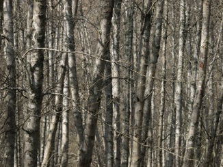
Habitats: Coastal woodland (mostly deciduous, much of it White Alder), bluffs, grassy hills, creekside undergrowth. Along the hiking trails there is redwood forest with seasonal streams.
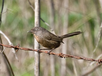
Unusual birds, sightings: Blue Grosbeak (July 18-25, 2015, Helen Kochenderfer); Black and White Warbler (Mar 7, 2013, Tom McCuller). Best known for raptors in the winter, for migrants in April and November. Excellent place to see (and hear) Wrentit. Good place for Lazuli Bunting in the summer along the trails that lead to higher elevations (Willow Creek Ridge).
Restroom facilities: None in the immediate area. Closest will be at Jenner. The Jenner Sea Store (by the gas station; it says "Jenner 'C' Store" on the side of the building) has outside portable restrooms. At River's End Restaurant north of town there are restrooms, but probably accessible only to customers. There are restrooms at the Sonoma Coast State Park visitors center, at the south end of town, across from the Jenner Sea Store. If you're headed south from this area, Bodega Bay is about five miles away where the Tides Restaurant at Tides Wharf has easily accessible restrooms.
Restaurants Nearby: On the south side of the bridge over the Russian River (on the map, it looks like it's on the north side of the bridge, but that's just the label) is The Sizzling Tandoor, which offers good if not exciting Indian food (I've heard it's best in the evening) with a good view (9960 Hwy. 1, Jenner, CA 95450, 865-0625; bring your binoculars out on the deck in the summer). The Jenner Sea Store in the town of Jenner has a deli with sandwiches and the like (10438 Hwy 1, Jenner, CA 95450, 865-2906) at the south entrance to town, or, if you feel like something more substantial, try the River's End Restaurant just north of the town (11048 Hwy 1, Jenner CA, 95450, 865-2484). There is also a new restaurant called Café Aquatica at 10439 Hwy 1, Jenner, CA 95450, across the street from the gas station, but I don't know anything about this place yet.
If you’re coming from the north and headed south to Bodega Bay, it may make sense to eat in Bodega Bay because there is more available there (see the Bodega Bay Overview page for restaurant suggestions), but there are choices along the highway in the vicinity of Jenner as well. To get into Jenner, you take the left fork in the road after the bridge if you're approaching this area from the south and are aiming further north on Hwy 1. The right fork, will take you east, away from the coast, into the town of Duncans Mills where Cape Fear Café (long one of the North Bay's best restaurants, although I haven't been recently) offers very good food with a southern flavor (25191 CA Route 116, 865-9246). Continuing further east on State Route 116 will take you toward Guerneville, Sebastopol, and Santa Rosa.
Related bird watching spots: The Jenner/Mouth of the Russian River/Goat Rock Beach area is about one mile north. Duncan's Landing is about four miles to the south. The Bodega Bay area is another six miles to the south from Duncan's Landing. See the Bodega Bay Overview page for information on Bodega Bay birding spots. Between Duncan's Landing and Willow Creek Road, there are places to see the coast at Wright's Beach and at Shell Beach. There is access to coastal trails at various locations between Jenner and as far north as Gualala.
Notes: 1. Willow Creek Rd. is low and at the bottom of bluffs. During and after rains, the road can be entirely flooded.
2. Some GPS devices may call Hwy. 1 "Coast Hwy. 1." Some devices will put you near Los Angeles rather than around Jenner if you input addresses using Hwy 1, depending on how their databases code the name (using Hwy 1 or Coast Hwy 1 or California Hwy 1, etc.). Before starting off using a GPS, be sure you are, in fact, headed where you want to go.
3. Gasoline is expensive in Jenner, but if you're low and going north, best to fill up in Jenner as there is only one other small, very expensive station between this area and Gualala, nearly 40 miles to the north. Gas is also very expensive in Bodega Bay, but at least it's only a few miles away from the Willow Creek Rd. area.
The bird in the photo: Wrentit, Willow Creek Rd., Jenner, March 9. 2011
All photos by the author, unless otherwise indicated
Maps by Google Maps
© Colin Talcroft, 2009, 2010, 2011.
Unless noted, all photos by the author. If you would like to use one of my images, please ask for permission for non-commercial use with proper credit or commercial use with proper compensation.